|
|
| |
Past Events
| When: | 29 Jul 06 | | Where: | Mt Charleston | | What: | Fletcher Canyon | | Distance: | 4 miles round trip | Elevation
Gain: | 1100 ft | | The Plan: | We will meet at the parking area across from the trailhead around 0900 (ish) and start the hike at 0915 (or so) by following the creekbed into Fletcher Canyon.
The Trailhead:
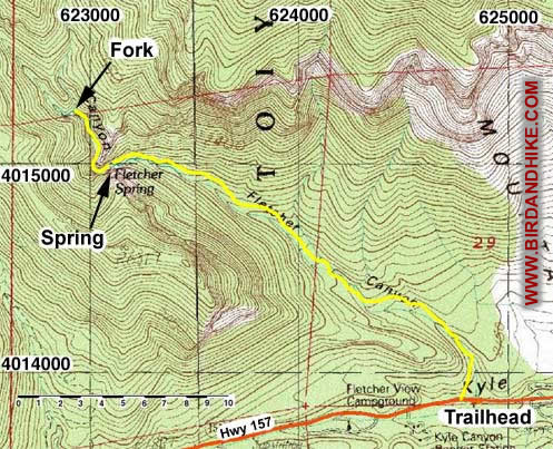
To get to the trail drive out to Mt. Charleston and go up Kyle Canyon. The trailhead is 0.5 miles west of the Highway 158 turnoff. The trailhead is marked by a sign on the north side of the road. There is parking available on the south side of the road.
The Trail:
The four mile version of this hike will take us up through a moderately strenuous graded canyon up to a spring, from here we will traverse a deep narrow canyon ending when the trail forks at the waterfall chute. From here those willing will push through the rock to the left in order to continue on to the forested slopes beyond.
| | | | |  | Click here for our pictures and comments.
Warning: Page may be slow to load due to images. |
|
|
|