|
|
| |
Past Events
| When: | 05 Aug 06 | | Where: | Mt Charleston | | What: | Bristlecone Trail | | Distance: | 6 miles - round trip | Elevation
Gain: | 600 ft | | The Plan: | We will meet at the lower trail head around 0900 and start the hike at 0915 (or so).
The Trailhead:
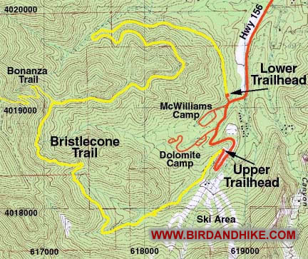
To get to the trail drive out to Mt.Charleston and go up Lee Canyon (This will be the second turn off of I95 the first being Kyle Canyon). The lower trailhead is located about 1 mile before the end of the road, but there are no signs for the turnoff. Driving up the canyon, drive past the long meadow and watch for signs to McWilliams Campground. After the "Campground Ahead" sign, but about 100 feet before the actual entrance to the campground, turn right on a well-graded dirt road. Drive about 100 yards to the big dirt parking lot at the end of the road. We will park here and walk down to the upper trail head.
The Trail:
This is a moderate six mile loop which passes through forests of pine-fir, aspen and bristlecone. In several places the trail opens up to provide great views of the surrounding mountains and of Lee Canyon. | | | | |  | Click here for our pictures and comments.
Warning: Page may be slow to load due to images. |
|
|
|